


Seven cities, 24 days and 334.7 kilometres of walking through the different landscapes that coexist within World Heritage Cities.
When I started Beyond the Postcard, the idea seemed relatively simple: travel through seven World Heritage Cities and explore what habitability means when heritage is not approached only as something to preserve or visit, but as part of an environment in which people continue to live.
Over 24 days, the OWHC Young Travelling Scholarship took me through Amsterdam, Bruges, Brussels, Luxembourg City, Strasbourg, Bern and Nice.
By the end of the journey, however, I was asking a slightly different question. I became less interested in whether a city could be described as simply “liveable” or “not liveable”, and increasingly interested in the different cities that coexist within the same physical city.
The city experienced by a visitor is not necessarily the city experienced by a resident. The heritage city managed by institutions overlaps with, but is not identical to, the commercial city. The same square can simultaneously be a monument, a workplace, an investment, a tourist attraction, a meeting place and somebody’s route home.
This became the central thread connecting the journey: how do these different urban landscapes coexist, overlap and sometimes compete within World Heritage Cities?
The scholarship did not provide the conditions for a formal comparative research project, nor was that its purpose. I was moving quickly, conversations were exploratory rather than representative, and each city offered very different access, contexts and opportunities.
What it did provide was something extremely valuable: a travelling exploratory framework.
I could walk, observe, speak with local people and heritage professionals, follow places suggested through those conversations and progressively compare the questions appearing from one city to another.
The result is not a ranking of seven cities, nor a measure of their habitability; it is an atlas of observations, encounters and questions.
Mapping the journey
The map below brings together the places that entered the seven city stories: landmarks, streets, neighbourhoods, public spaces, institutions, landscapes and other locations that shaped an observation or conversation during the journey.
It is not intended as a complete inventory of what I visited, nor as a tourist guide. I prefer to think of these points as places and encounters: locations that helped produce a question, reveal a contrast or change the way I understood a city.
Mapping them also makes one of the main ideas of the project easier to see. Heritage does not operate only at the scale of monuments or within the limits of a protected polygon. The questions that repeatedly emerged — housing, tourism, mobility, public space, landscape, identity and everyday use — connect heritage areas to much wider urban systems.
Explore the map by clicking on the different places and cities below.
A consistent way of looking, without forcing consistent answers
I used a relatively simple workflow throughout the journey: walk → notice → talk → follow → map → reflect
Walking provided the first reading of a place. Rather than moving only between recognised landmarks, I paid attention to what happened between them: changes in street use, density, commerce, vegetation, mobility, visitor presence, housing and the possibility of simply remaining in public space.
Observation was then complemented by conversations. Meetings with OWHC representatives, site managers, researchers and other local actors often introduced dimensions that were impossible to infer from the street alone. Informal encounters could do the same.
The next step was especially important: follow. A conversation could change the itinerary. A comment about housing could lead to another neighbourhood; a question about accessibility could make a vertical connection suddenly important; a recommendation could move the project far beyond the places initially planned. In that sense, the route was partly produced by the cities themselves.
Mapping gave these encounters a common language: where. Where does visitor-oriented commerce become dominant? Where does residential life become more visible? Where does the heritage area meet the rest of the city? Where do physical or social transitions occur? Where do different people experience apparently different versions of the same urban environment?
The method remained relatively consistent. What I found did not have to be.
Walking as method, not as a metric
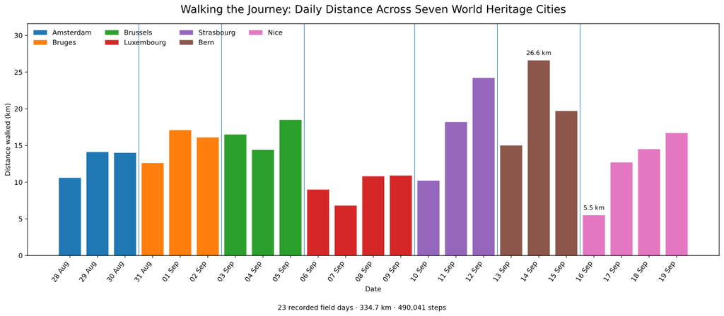
Walking was the main way I encountered the cities, so I became curious about what the movement data from the trip would look like when placed together.
Across 23 recorded field days, I walked approximately 334.7 kilometres, corresponding to 490,041 steps.
This does not measure the quality or intensity of the work — some of the most informative days involved relatively little walking — but it provides another trace of how the project was carried out.
The arrival day was generally lighter. Travel reduced the available time, and I deliberately used those first hours for relatively unstructured exploration: following the most obvious routes, getting a sense of scale and allowing an initial image of the city to form before looking more deliberately.
I also made a conscious decision to travel exclusively by bus between the scholarship cities, rather than flying. This was partly aligned with the scholarship’s emphasis on lower-impact mobility, but it also became unexpectedly relevant to the project itself. Moving overland made the journey between cities visible rather than abstract. Instead of disappearing from one airport and reappearing in another, I could follow a broad north–south transect of Western Europe and watch landscapes, settlement patterns, infrastructure and urban scale gradually change between stops.
That choice was physically demanding. The intercity journeys added up to more than 35 hours on the road, excluding longer breaks and waiting times, and some transfers significantly reduced the time and energy available on arrival days. Yet the slower movement also gave the itinerary a clearer geographical dimension. It made the distance covered between Amsterdam and Nice tangible, and even created unexpected encounters with places outside the formal route, including stops in Annecy and Marseille. These were not part of the scholarship case studies, but they helped situate the seven cities within a much broader European landscape.
In that sense, the journey between the cities also became part of the observation. The project was not only about seven isolated destinations, but about moving through the territory that connected them. The fatigue was real, but so was the value of experiencing the transition itself rather than treating mobility as a neutral gap between field sites.
On average, I walked around 11.3 km on arrival days, compared with almost 16 km on subsequent days.
There were important exceptions. Luxembourg recorded the lowest overall walking intensity because free public transport, previous familiarity with the city and a meeting-heavy agenda allowed me to shift much more of the visit towards conversations and institutional encounters. Nice had the shortest single day, after a journey of more than nineteen hours from Bern involving two transfers.
At the other extreme, one day in Bern reached 26.6 km, as the exploration moved well beyond the historic centre into the surrounding landscape.
The numbers therefore reinforce something that became methodologically important to me: distance travelled and knowledge produced are not the same thing.
Walking was a method for encountering the city, but conversations, pauses, revisits, long overland transitions and simply remaining in a place were equally important.
What began to repeat across the cities?
The cities were deliberately not forced into the same narrative.
Amsterdam is not Bruges. Bruges is not Nice. Bern’s relationship with landscape cannot simply be transferred to Brussels. Luxembourg’s topography produces forms of connection that emerge very differently in Strasbourg.
Still, some questions repeatedly returned. They did not necessarily produce the same answers. That is precisely what made comparison useful.
1. Can historic centres remain residential places?
Perhaps the strongest recurring question was residential continuity.
In Amsterdam, an internationally recognised historic urban landscape remains simultaneously residential, infrastructural and intensely visited.
In Bruges, conversations highlighted the economic competition between residential use and hotels or visitor-oriented businesses within an exceptionally preserved historic centre.
In Brussels, the issue appeared in another form. Discussions with local heritage professionals drew attention to upper floors in the central area that may remain vacant or be used for commercial storage, even while housing pressure makes living close to the centre difficult for many people.
The contradiction is important. A building can be physically preserved while some of its capacity to support everyday urban life disappears.
The question therefore became more precise than simply asking whether tourism “displaces residents”: who can afford to occupy the historic city, and for what purpose?
Historic centres contain several forms of value simultaneously: heritage, residential, commercial, symbolic, visitor and investment value.
How these are balanced affects whether central heritage areas remain places where people can actually construct ordinary lives.
2. Tourism does not only occupy the city. It can reorganise it.
Tourism was visible throughout the journey, but visitor numbers alone rarely explained what interested me most. What mattered was how urban functions reorganised themselves around visitors.
In Bruges, highly central areas repeatedly concentrated chocolate, beer, fries, souvenirs and other tourist-oriented activities.
Similar processes appeared elsewhere in different forms. A grocery store and a souvenir shop can occupy almost identical physical units. Spatially, however, they support very different urban relationships.
The issue is therefore not simply whether tourism is present.
It is what kinds of activities become economically viable because of it, what they replace or coexist with, and for whom the resulting city functions.
Nice complicated this interpretation in a particularly useful way.
Its UNESCO property does not focus on the medieval old town itself, but on the urban landscape produced as Nice developed into a cosmopolitan winter resort.
Hotels, promenades, gardens, villas, foreign places of worship and infrastructure designed for visitors are not merely contemporary pressures imposed on an older heritage landscape.
They are part of the heritage being recognised.
Nice therefore showed why tourism cannot be treated as the same urban phenomenon everywhere.
Sometimes tourism transforms heritage. Sometimes historical tourism helped create the heritage that is now being protected.
The contemporary consequences still need to be questioned, but the historical relationship matters.
3. Heritage does not stop at the World Heritage boundary
Some of the most useful moments of the journey occurred when I moved away from the most obvious heritage landscape.
In Strasbourg, walking from the Grande-Île and Neustadt through European institutions, parks and eventually across the Rhine into Germany made the limitation of treating the UNESCO property as an isolated unit particularly clear.
In Bern, moving outward from the Old City revealed how intimately the heritage centre depends on a larger landscape of river, hills, forests and agricultural land.
In Luxembourg, the relationship between upper and lower city, valleys, bridges, lifts and neighbourhoods made connectivity impossible to understand through monuments alone.
A formal heritage boundary is essential because it tells us where particular Outstanding Universal Value has been identified and protected.
But it cannot describe every system that makes that heritage area function.
Residents work outside it. Visitors arrive through infrastructure outside it. Housing markets operate across it. Environmental systems ignore it. People may develop attachment to a heritage area while living far beyond it.
The heritage site is therefore better understood as part of a wider urban ecosystem and this was one reason the mapping became useful to me. It allows the formal heritage geography to sit beside the much less tidy geography of lived experience.
4. Preserving buildings is not the same as preserving urban life
Another recurring theme was the importance of intangible and functional continuity.
Cities are not made only through façades, monuments and urban form. They are also made through habits, commerce, languages, memories, movement, social relationships and repeated ways of using places.
A street can remain architecturally intact while changing profoundly in who uses it and what it is for.
The opposite is also true. Adaptation does not necessarily destroy heritage.
In Nice, hotels can remain hotels, promenades remain spaces for walking and religious buildings continue performing religious functions.
In Amsterdam, canals continue organising movement and urban life centuries after their construction.
In Strasbourg, very different historical layers remain legible because the city changed without completely erasing what preceded them.
The question is therefore not simply: has this place changed? Cities necessarily change.
A more useful question may be: what kinds of change allow heritage to remain meaningful as part of everyday life?
One city can contain many cities
This was perhaps the most important idea that emerged from the entire journey.
There is rarely only one version of a city. The same physical space can simultaneously belong to:
The resident city — where people sleep, shop and construct routines;
The visitor city — organised through landmarks, hospitality and consumption;
The heritage city — interpreted through conservation and institutional responsibility;
The commercial city — shaped by land values and economic opportunity;
The institutional city — structured around administration, governance and public services;
And the remembered city — formed through personal attachment, identity and collective narratives.
These cities overlap geographically. They do not necessarily overlap experientially.
Brussels made this particularly visible. Within a relatively short walk, Grand-Place, Marolles, Sablon, the Royal Quarter and the European institutions can feel like different urban worlds.
A city may therefore be physically continuous while being functionally and experientially fragmented.
This connects directly with a broader question that interests me beyond this journey: how can different groups experience apparently different urban landscapes while occupying the same geographical city?
That question is where the exploratory nature of Beyond the Postcard starts to connect with GIS and more analytical research.
What geoinformation adds
Geoinformation (namely through Geographic Information System) does not turn these observations into objective measurements simply because they appear on a map.
That is not what I am trying to do.
Its value is that it forces qualitative observations to retain their spatial context. A conversation happened somewhere. A commercial transition happened along a particular street. A resident recommendation pointed towards a particular neighbourhood. A sense of disconnection appeared between particular places.
Once located, those observations can potentially be compared with other forms of evidence: housing prices, land use, tourist accommodation, demographics, mobility, accessibility, environmental data or participatory mapping. This is where I increasingly see this approach fitting.
Not as a replacement for more rigorous spatial or quantitative analysis, but as a complement to it.
Structured urban datasets are very good at helping us ask: how much? Where? How has it changed? Who is affected?
Walking, observation and participatory knowledge can introduce different questions: How is this experienced? What does this place mean locally? What contradiction is hidden behind an aggregate value? Where should we look more closely?
The journey therefore became a small methodological experiment as much as a travel project.
What the journey ultimately changed
I began Beyond the Postcard thinking primarily about habitability in World Heritage Cities.
I ended it thinking more about relationships.
Between preservation and adaptation. Residents and visitors. Material and intangible heritage. The protected property and the wider city. Economic value and everyday use. Landscape and built form. The physical city and the many different ways in which it is experienced.
The seven cities did not produce one model of a “successful” living heritage city. That would probably be the wrong conclusion.
What they showed instead was how strongly context matters.
Amsterdam’s canals remain living infrastructure as well as heritage. Bruges raises particularly visible questions about preservation, commercial specialisation and residential continuity. Brussels reveals how several urban worlds can occupy one city without always connecting easily. Luxembourg makes topography, accessibility and participation particularly difficult to separate. Strasbourg demonstrates continuity through historical layers and cross-border connection. Bern shows how profoundly landscape and accessible nature can structure urban experience. Nice reminds us that international mobility and visitors are not always forces external to heritage; in some cases they are part of its historical formation.
What remained consistent was the usefulness of treating heritage as part of a living urban system, rather than as a collection of exceptional objects.
And many of the most revealing moments were surprisingly ordinary: a few streets beyond the tourist route; an unused upper floor above a busy shop; a bridge between two levels of a city; a quiet residential street beside an internationally recognised monument; a park occupied equally naturally by locals and visitors; a conversation that made me change direction.
Those moments are difficult to reduce to a single indicator. But they are often exactly where better questions begin.
Beyond the postcard
World Heritage recognition asks cities to preserve something considered exceptional from the past.
But World Heritage Cities cannot survive only as records of what they once were.
They must also accommodate people who live there now, people arriving from elsewhere, changing economies, new forms of mobility, environmental pressures, contemporary identities and futures that cannot be completely predicted.
Perhaps the challenge is therefore not to choose between heritage and change.
It is to understand which kinds of change allow heritage to continue having meaning as part of everyday urban life.
After seven cities, that is what I ultimately found beyond the postcard.